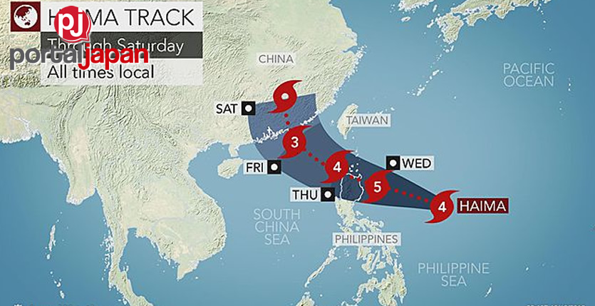
Following deadly flooding caused by Typhoon Sarika, the Philippines brace for another blow by Super Typhoon Sarika late this week.
Haima, referred to as Lawin in the Philippines, quickly strengthened over the weekend, reaching typhoon status on Sunday morning, local time.
On afternoon, local time, Haima reached super typhoon status, with sustained winds over 240 km/h (150 mph), equivalent to wind speeds of a Category 4 hurricane in the Atlantic Ocean.

Haima is forecast to track over the northern part of Luzon in the northern Philippines. Landfall on the eastern coast of Luzon is likely to occur on Wednesday afternoon or Wednesday night.
It could make landfall with wind gusts over 275 km/h (173 mph), causing major damage to areas in its path. Winds of this magnitude are capable of major structural damage, including completely removing exterior walls and roofs.
The extremely strong winds in combination with the torrential rains will down trees and may cause widespread power outages that could linger even after the storm has passed.
With Haima, new rainfall amounts of 75-150 mm (3-6 inches) are expected through the middle of the week. This additional rain will escalate the risk for mudslides, especially in the higher elevations.
Coastal areas north of Haima’s center will also need to watch for coastal flooding. In combination with gusty, onshore winds and high tides, feet of water could inundate areas near the coast.
Source and image: Accuweather


Join the Conversation