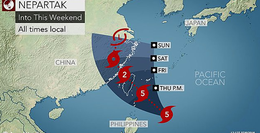
Super Typhoon Nepartak will target Taiwan and Japan’s southern Ryukyu Islands with flooding rain and damaging winds later this week. Threats to Eastern China will then follow.
Nepartak rapidly intensified into a super typhoon early Wednesday local time with sustained winds reaching 278 km/h (173 mph).
Lives and property will be severely threatened as Nepartak tracks dangerously close to the Yaeyama Islands of Iriomote and Ishigaki and then makes landfall in Taiwan.
The Yaeyama Islands will face tropical downpours and typhoon-force wind gusts.
The northern half of Taiwan will bear the brunt of Nepartak. These areas will face flooding rainfall of 150-300 mm (6-12 inches) and destructive winds of 160-210 kph (100-130 mph), according to AccuWeather Meteorologist Adam Douty.
The islands will also be subject to coastal flooding, especially near and north of Nepartak’s track.
Residents are encouraged to take necessary precautions to protect lives and property ahead of the typhoon and heed evacuation orders.
The worst conditions across the southern Ryukyu Islands will be Thursday into Thursday night.
After tracking south of the Yaeyama Islands, Nepartak will make landfall in eastern Taiwan on Thursday night followed by a second landfall in eastern China on Friday night.
“Wind damage is expected in northern parts of Taiwan, with the worst conditions occurring in Hualien County and Yilan County,” according to Douty.
Flooding rain and mudslides will also threaten these areas.
Nepartak’s worst impacts will be felt across Taiwan on Thursday night into Friday. Heavy rain and strong winds will then spread along the eastern China coastal plain Friday afternoon into the weekend.

“The worst impacts in eastern China will be in Fujian and Zhejiang provinces,” according to Douty.
“Typhoon-force winds will be common near the coast, and 100-200 mm (4-8 inches) of rain will cause flooding,” he said.
Residents of Taiwan and eastern China should closely monitor the expected track of Nepartak. Any shift in the cyclone’s path will result in changes to where the worst impacts are expected.
A farther west track could renew the major flood risk in Jiangsu and eastern Anhui provinces, which endured deadly flooding rain late last week. Even in this scenario, Nepartak’s rain should remain east of the hardest-hit areas from Hefei to Wuhan.
Nepartak is expected to weaken significantly as it moves inland across eastern China and transitions into a tropical rainstorm as it moves northward toward Shanghai on Sunday.
“As the system weakens, winds will become a lesser concern and flooding rainfall will be the main concern,” Douty said.
While Nepartak ended the tropical cyclone drought in the basin, it is not expected to be followed by a flurry of tropical activity.
“The window for development looks to slam shut by this weekend,” AccuWeather Senior Meteorologist Jason Nicholls said. “Then, I do not see much opportunity [for further development] until late July.”
Source and image: Accuweather


Join the Conversation